Hydrogeological Characterization Studies
 Hydrogeological characterization studies cover a broad range of applications and services. In the broadest sense these studies are designed to characterize either the earth matrix which is controlling groundwater flow or the quality of the ground water. Typical applications include:
-
Determining Aquifer Thickness
-
Mapping Vertical Extent and Lateral Continuity of Confining Units
-
Determining Areas of Probable Conduit Flow
-
Mapping the Vertical and Horizontal Extent of Contaminant Plumes
-
Determining the Depth to Saltwater
Geophysical Methods
Electrical Resistivity Imaging (ERI)
The ERI method develops two-dimension vertical cross-sections which depict the distribution of resistivity. The resistance of earth materials is controlled by both the matrix (soil/rock) resistivity and the groundwater resistivity. As the groundwater conductivity increases (becomes more ionic) the fluid conductivity dominates overall bulk resistivity. Therefore, ERI and other electrical methods are very effective in delineating ionic groundwater contamination and determining the depth to salt water. Various geological layers and features; e.g., clay confining units, fractures or sinkholes that control the groundwater flow can also be characterized. Depth of investigation is controlled by transect length in that maximum depth of investigation is typically 20 to 25 percent of the total transect length. Where site conditions allow, depths of 250 to 350 feet are usually achieved.

Electromagnetics (EM)
The EM method measures the bulk conductivity of the earth materials to a particular depth range. By varying the instrument configuration different depths of evaluation can be obtained. Depths of evaluation range from approximately 10 to 200 feet. EM data is usually collected along series of transects with data values being collected at set station intervals. Data collection can be integrated with a differentially corrected GPS to allow for a very rapid assessment of site conditions.
Time Domain Electromagnetics (TDEM)
Vertical profiles of electrical resistivity can be readily obtained using TDEM. The TDEM method is superior to older resistivity methods, especially when depths of greater than 100 ft are required. The TDEM method develops resistance values at discrete depths. These resistivity values are then modeled to provide to provide a layered solution that describes the distribution of major geo-electrical layers with depth. By varying receiver frequency and transmitter loop size, depths from 30-40 feet to 2,000-2,500 ft can be obtained. The TDEM method can be used to both map hydrogeologic layers and determine the depth to salt water
.
Borehole Methods
Borehole logging provides precise hydrogeological data collected from inside of the borehole. Physical earth properties such as bulk resistivity, conductivity and gamma radiation can be readily obtained. Stratigraphic contacts, fractures and voids are measured using borehole calipers and imaged using acoustical and optical televiewers. This combined information can be used to establish a very high-resolution view of the hydrogeological matrix. Fluid resistivity and in-flow/out-flow contributions from fractures can also be measured to better understand water quality and flow patterns with the aquifer system.
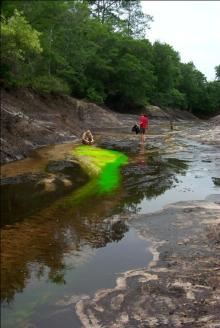
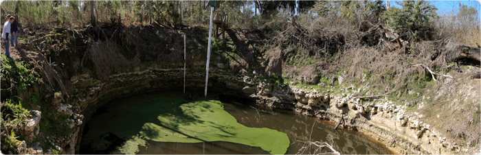
Dye Trace Studies
Properly implemented dye trace studies can provide information regarding groundwater flow and discharge patterns within karst aquifer systems. Such information can yield an understanding of the karst conduit system and allow for a calculation actual flow velocities.