


Borehole Geophysics
Borehole geophysics can provide precise information regarding the soil and rock properties at specific depths. The tests include:
-
Resistivity and conductivity – used to measure the electrical resistance of the borehole environment and surrounding soil/rock. Useful for determination of lithology, water quality, water bearing zones and stratigraphic correlation.
-
Spontaneous Potential – Measures electrical potentials between the borehole fluid and the surrounding rock and fluids. It can be used in the determination of lithology and water quality. Collection of spontaneous-potential logs is limited to water or mud filled open holes.
-
Fluid Resistivity – Measures the electric resistivity of water in the borehole. The changes typically reflect differences in dissolved-solids concentration of water. Fluid-resistivity logs are useful for delineating water producing or receiving zones, water quality and saltwater encroachment.
-
Single-Point resistance logs – Used to locate contamination, saltwater interface, geologic changes and water quality changes.
-
Gamma – Used to detect soils and rocks with elevated levels of naturally occurring gamma radiation. The most significant naturally occurring sources of gamma radiation are potassium-40 and daughter products of the uranium and thorium decay series. Clay and shale bearing rocks commonly emit relatively high gamma radiation. It has been extensively used in detecting shales for natural gas production.
-
Caliper Studies –Used to measure borehole diameter and fracture/cavity size. The changes in diameter can be related to well construction, rock hardness, swelling shales and to fracturing or caving along the borehole wall. Because borehole diameter commonly affects other log responses, the caliper log is useful in the analysis of other geophysical logs.
-
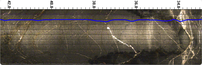
Optical and Acoustical Imaging - Used to provide 360 degree images of the borehole walls. Can be useful to map strike and dip of fractures, locate voids, map geologic strata changes, estimate competency of the rock. Optical imaging provides a video image. It requires either an open borehole or clear borehole fluid. Acoustical imaging uses sound waves to produce an image of the borehole. It requires a fluid filled hole. The fluid does not need to be clear.
-
Deviation – Used to map the verticality and route of the borehole
-
Flow Tests – Used to determine direction and velocity of vertical ground water flow within the borehole. Depending on flow rates, the tests can be either heat pulse, electromagnetic or spinner instruments
-
Temperature – Used to record a continuous profile of the temperature of the borehole. Useful for mapping water bearing zones and vertical flow direction in the borehole. Should be run first in the undisturbed hole.
Typically the boreholes need to be 3 to 12 inches in diameter and need to be cased within zones of unconsolidated sediments. The boreholes can range from tens of feet to thousands of feet in depth.
