


Pre-Columbian Artifacts
Cordillera de Mérida mountain range, Northeastern Colombia
 A pipeline is planned to transport oil from the Cordillera de Mérida mountain range of northeastern Colombia west towards the Pacific Ocean. An archeological investigation is being conducted by others along the proposed pipeline route to determine potential areas of historical significance. As part of the project, GeoView was asked to provide a geophysical survey within twelve areas to help identify pre-Columbian artifacts prior to the construction of the pipeline. These artifacts included including metal tools, pottery, cooking pots, gold ear and nose rings and other artifacts. The geophysical investigation was conducted using frequency domain electromagnetics (EM-38), total field magnetics (magnetics) and a hand held metal detector. The investigation was conducted over a three week period in 2012.
 Each site is was approximately 2400 square meters in size. The sites were mostly grass covered with scattered trees and light underbrush. The EM-38 portion of the geophysical investigation was conducted using a Geonics EM38-MK2 (EM-38). The EM method responds to the presence of metals that are both iron-bearing (ferrous) and non-ferrous (e.g., aluminum or brass). For this study EM-38 measurements were taken using a vertical dipole orientation. This orientation provided bulk conductivity and inphase readings for soils to an approximate depth of 1.5 meters below land surface. The magnetics survey was conducted using a Geometrics 859 Cesium Vapor magnetometer. For the anticipated size of the targets, the anticipated depth range of sensitivity was 2 to over 5 meters, depending on target size and orientation. In addition to the frequency domain electromagnetics and total field magnetics, a traditional hand held metal detector was used at each survey area. The purpose of the hand held metal detector was to help identify small, shallow metallic objects that might get missed by the EM-38 and G-859 due to their greater depth of investigation and broader sensing area
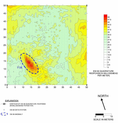 Numerous features of interest were identified at each site. Site maps and coordinates of each anomaly were provided. The artifacts were then able to be properly excavated and documented prior to the commencement of the pipeline construction.