Geophysics should be an integral part of any geotechnical site characterization study. GeoView has performed thousands of geophysical surveys as part of geotechnical characterization studies. The projects are managed by licensed professional geologists who have the tools and the knowledge to bring the appropriate method to each job. The following are common applications of geophysics in these studies.
- Methods include seismic refraction, seismic reflection, electrical resistivity imaging
Mapping faults
- Methods include seismic reflection and refraction, electrical resistivity imaging, MASW and VLF surveys
Determining the p-wave velocities of the soils and rock. Useful in rippability studies.
- Methods include seismic refraction, crosshole and downhole seismics
Determining the shear-wave velocities of the soils and rock. Useful in Vs30 studies.
- Methods include MASW, downhole and crosshole seismics and shear wave refraction
- Methods include seismic refraction, ground penetrating radar, electrical resistivity imaging and borehole geophysics
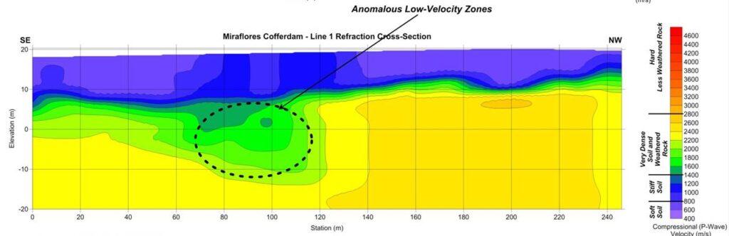
Mapping shallow voids.
- Methods include ground penetrating radar, MASW and slab impulse response (for voids directly below concrete) techniques.
Mapping groundwater flow
- Borehole geophysics and dye tracing
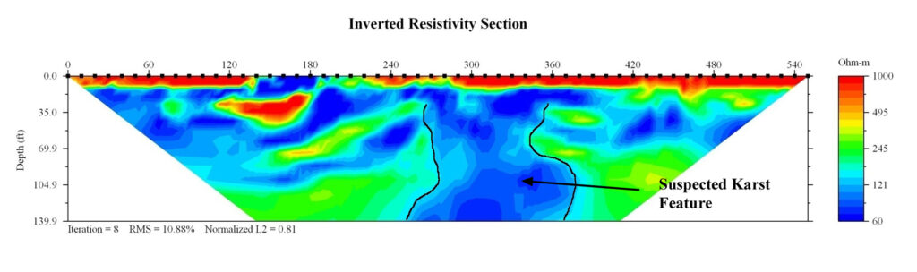
Mapping karst/sinkhole features
- Methods include seismic refraction, seismic reflection, electrical resistivity imaging, ground penetrating radar, gravity, frequency domain electromagnetics and MASW.
Determining Electrical and Thermal Properties of the subsurface
- 4-pin electrical resistivity soundings and in-situ lab thermal resistivity studies
The data can be used to provide continuous profiles from SPT and CPT boring data and to help with the placement of future test locations. The results can be incorporated in an AutoCAD or ArcView format as part of the final report. GeoView has performed a broad array of geological and geotechnical studies. These have ranged from small residential karst studies to foundation design studies for Liquefied Natural Gas facilities.
Hydrogeological
Hydrogeological characterization studies cover a broad range of applications and services. In the broadest sense these studies are designed to characterize either the earth matrix which is controlling groundwater flow or the quality of the ground water. Typical applications include:
- Determining Aquifer Thickness
- Mapping Vertical Extent and Lateral Continuity of Confining Units
- Determining Areas of Probable Conduit Flow
- Mapping the Vertical and Horizontal Extent of Contaminant Plumes
- Determining the Depth to Saltwater
Geophysical Methods
Electrical Resistivity Imaging (ERI)
The ERI method develops two-dimension vertical cross-sections which depict the distribution of resistivity. The resistance of earth materials is controlled by both the matrix (soil/rock) resistivity and the groundwater resistivity. As the groundwater conductivity increases (becomes more ionic) the fluid conductivity dominates overall bulk resistivity. Therefore, ERI and other electrical methods are very effective in delineating ionic groundwater contamination and determining the depth to salt water. Various geological layers and features; e.g., clay confining units, fractures or sinkholes that control the groundwater flow can also be characterized. Depth of investigation is controlled by transect length in that maximum depth of investigation is typically 20 to 25 percent of the total transect length. Where site conditions allow, depths of 250 to 350 feet are usually achieved.